Coleman Deming - July 29, 2013
Although the Coleman-Deming route has had fewer climbing parties this season due to access issues, the route has been travelled enough to have presently formed a bootpack. Running water is available at Harrison, Hogsback and Gargoyle camps. Hogsback and Eagles Nest camps are now fully melted out and offer many dry campsites. The snow camps at the Black Buttes show signs of use, however, overnight users should evaluate their exposure to rock fall hazard before setting up tents in an area beneath the cliffs. No airy crevasse crossings exist on route at this time. Pumice ridge at 9,200 ft. and the growing rock step on the Roman Wall at 10,500 ft. currently prove to be the routes largest obstacles. Colfax Peak still shows evidence of snow and ice fall. Parties should minimize their time beneath Colfax and negotiate a route wide of its debris zone. Climbers should also be aware of a large crevasse near Grant Peak on the summit plateau and remain roped while near this hazard. Lastly, no mountain toilets exist on Mt. Baker this season. Please come prepared with Blue Bags or an equivalent waste removal system to pack out your human waste. Thanks and enjoy your time on the mountain.
 |
| Mount Baker's north side as viewed from below Black Buttes. |
 |
| Route up the Coleman Glacier towards Pumice Ridge. |
 |
| Hogsback Camps with Mount Baker in the background. |
Coleman Deming - July 19, 2013
Heliotrope Ridge Trail is clear of snow to Hogsback Camps and Harrison Camps. 8-10 downed trees are currently across the trail. Dry campsites exist at both campsites and ample running water is available. Wildflowers are currently in full bloom and the route up the Coleman Glacier appears to be straightforward and direct. Pumice Ridge is bare rock at this time. Please remember to pack out all garbage and human waste using proper removal systems. Happy climbing!
 |
| Hogsback Campsites |
 |
| Route above Hogsback Campsites. |
 |
| Mount Baker's north side from Heliotrope Ridge. |
Coleman-Deming - June 16, 2013
 |
| Drainage adjacent to Heliotrope Ridge Trail. |
 |
| Hogsback Camps with Mount Baker in the background. |
Early season conditions exist on the north side of Mt. Baker. The skiers route which leaves from behind the bathrooms from the Heliotrope Ridge trailhead leading to Grouse Creek drainage is melted out. Further use of this approach will cause damage to vegetation, so climbers and skiers should stick to the Heliotrope Ridge Trail. Because Heliotrope Ridge trail is snow covered after one mile of travel, some route finding is required to reach Hogsback camps. About 4 dry campsites at Hogsback at this time. As of yet, no running water is exposed and users should bring enough fuel to melt snow into water. There are also a few dry campsites at Gargoyle Rock, where running water is available.
 |
| Saddle between Colfax Peak and Mount Baker. |
 |
| Mount Baker's Roman Wall. |
The
Coleman-Deming route is direct and consistent with no open or airy
crevasse crossings. Falling ice and rock is evident on Colfax Peak and
the Coleman Headwall. Climbers have been observed giving these features a
wide birth. Pumice Ridge is still snow covered. Sun cups have not yet
developed above 5,000 ft. and the Roman Wall is clean with excellent
corn snow. There are no mountain toilets on Mt. Baker this season and
climbers should come prepared to pack out all human waste using Blue
Bags or another system. Blue Bags are available at the Forest Service
station in Glacier, WA. Please also remember to register for your climb
there. Good luck and happy climbing!
 |
| The north side of Mount Baker. |
Coleman-Deming - June 1, 2013
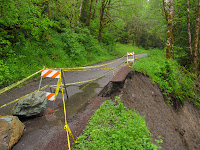 Glacier Creek road is closed at the Thompson Creek bridge approximately 1 mile from highway 542. The road is closed due to a washout at 2.7 mile mark. Only hikers or bikers can continue past the closure for another 6.5 miles before reaching snow on the road. Roughly .5 miles of snow covered road still exists before reaching the Heliotrope Ridge trailhead.
 The bridge across Grouse creek is fully melted out as is the beginning of the Heliotrope trail. Please remember to remove all your flagging on your way out if you placed any on the way in. Flagging left behind becomes litter in the forest. Boots, gaitors and trekking poles are advised for the hike. Route finding skills are necessary for the trail.


 Glacier Creek road is closed at the Thompson Creek bridge approximately 1 mile from highway 542. The road is closed due to a washout at 2.7 mile mark. Only hikers or bikers can continue past the closure for another 6.5 miles before reaching snow on the road. Roughly .5 miles of snow covered road still exists before reaching the Heliotrope Ridge trailhead.

 The bridge across Grouse creek is fully melted out as is the beginning of the Heliotrope trail. Please remember to remove all your flagging on your way out if you placed any on the way in. Flagging left behind becomes litter in the forest. Boots, gaitors and trekking poles are advised for the hike. Route finding skills are necessary for the trail.