Coleman - Deming Route - August 29, 2011
Glacier Creek Road is open and clear to the Heliotrope Ridge Trailhead and the Mount Baker Vista. Please drive cautiously.
The Grouse Creek bridge crossing is now melted out and extremely dangerous to cross at the site of the old footbridge. Hikers and Climbers are being advised to cross at your own risk far below or above this site. The remaining avalanche debris that destroyed the footbridge and fills the drainage is dangerously thin in spots and contains many holes and cracks which lead to the steep and narrow creek some 25 feet below. An accident at this hazard could prove fatal and great precaution should be taken when crossing the creek above or below.


The Coleman-Deming route is looking excellent for this late in the season. The route leaves the Hogsback and ascends suncupped slopes up to the Black Buttes. Few crevasses are exposed through this section which is very uncharacteristic for this point in the season. Climbers should be aware though of the hazards that lurk beneath the surface as well as the importance of setting out early in the morning and getting a good alpine start to the climb. From the Black Buttes the route continues skirting along the Coleman Glacier, under Colfax peak and then to the saddle. Again few crevasses are visibly being stepped over through this leg of the climb. The bergschrund at roughly 8,800 ft. is sagging and opening more to either side, but overall showing good coverage and stability for this late in the summer. Pumice Ridge is nearly stripped of its snow and melted out fully to the rock while the Roman Wall has various staircase bootpacks that ascend to the summit plateau. As the rock band continues to melt out at the top of the Roman Wall, footing in this section will become poor. Climbers are urged to use caution while ascending or descending through this area and to be contientious not to congest this common bottleneck. The summit register is now melted out and all visitors are free to sign in the logbook. Please do not, however, dispose of your trash or put any items into the box, thank you. Mountain toilets can be found at the Black Butte Camps and the Hogsback Camps. Please be sure to sweep your camps and pack out all other food scraps, and garbage before departing. Be safe and happy climbing!

Coleman - Deming Route - August 15, 2011
Glacier Creek Road is clear to Heliotrope Ridge Trailhead. A few deep potholes exist so drive slowly.
Heliotrope Ridge Trail is snow free all the way to the Hogsback campsites, except for Grouse Creek drainage, which can still be crossed on snow but is melting out fast. The trail to Harrison Camp and Survey Rock is also mostly snow free and rivers are crossed via hopping rocks. Trekking poles are recommended.
Large runnels and suncups are present on snowfields below 8,000 ft. A few inches of fresh snow was received above 9,000 ft in the last two days. Snow is becoming soft by late morning and firming up overnight.
The route up the Coleman-Deming glacier is in excellent shape for climbing and there are still no major route-finding obstacles. A bootpack leaves Hogsback Ridge and travels directly up the Football Field, past Black Buttes, and crosses two large snow bridges at about 8,300 ft and 8,800 ft respectively. These bridges should remain in good condition for at least a few weeks. Pumice Ridge still contains patchy snow but is becoming more rocky with time. The rock band at the top of the Roman Wall is beginning to be exposed as snow continues to melt, but the route is still straightforward and direct to the Crater Rim. Hogsback Ridge currently contains 20-25 dry campsites with more melting out quickly. Harrison Camp and Gargoyle Rocks also contain 3-6 dry campsites each. Running water is available at all campsites except Black Buttes. Users are reminded not to move rocks or construct walls around campsites. Toilets are available at both Hogsback Ridge and Black Buttes. Be sure to carry Blue Bags for use on route and remember to pack out all garbage. Do not put Blue Bags or garbage in toilets! Happy climbing!
 |
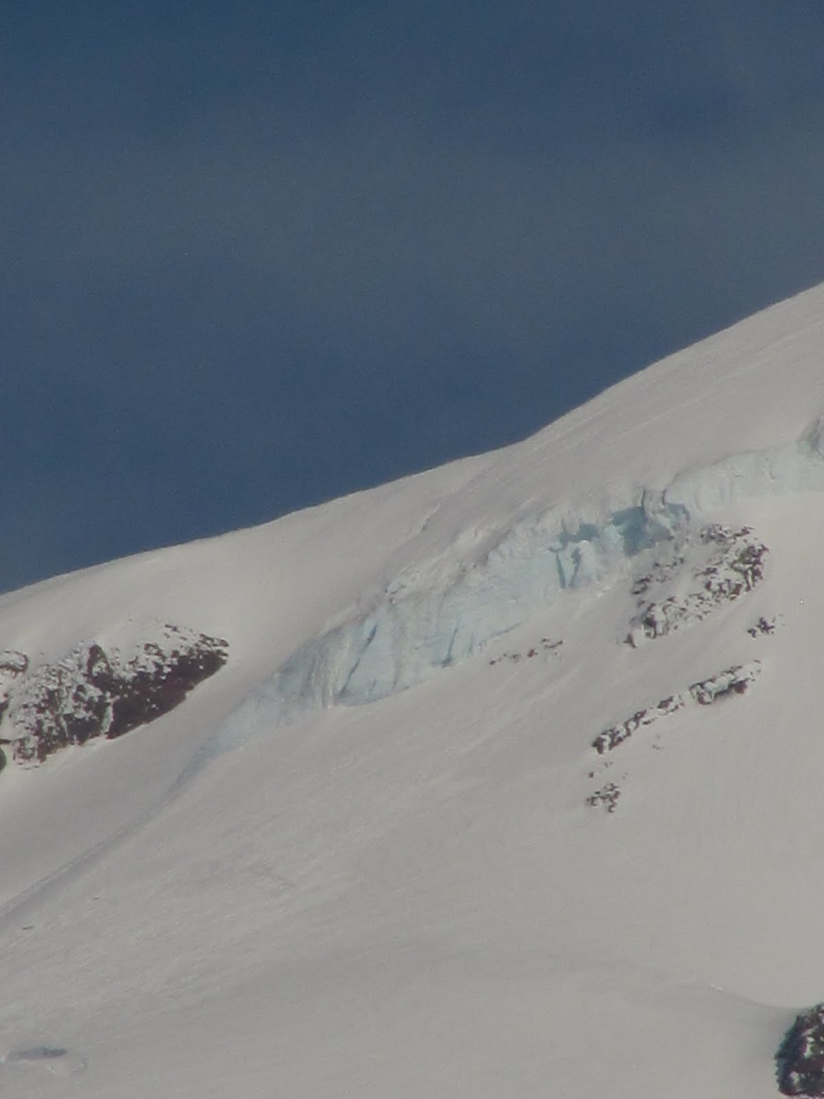
Seracs on the lower Coleman Glacier provide an excellent
opportunity for those looking to hone their ice climbing skills. |
Heliotrope Ridge Trail to Hogsback Camps to Coleman-Deming Glacier - August 1, 2011
|
|
| Mt. Baker and Hogsback Campsites from the west. |
Heliotrope Ridge Trail is mostly snow free all the way to Hogsback Campsites, except for Grouse Creek and other snowy patches above 5000ft. The trail to Harrison Camp also contains patchy snow and open river crossings. Remember to stay on established trails and please do not cut switchbacks.
 |
| Hogsback Ridge is mostly snow free. |
Mid-season snow conditions are prevalent on the mountain with large suncups and runnels developing below 8000ft. Some new snow has been received above 9500ft in the past two weeks. Snow is still firming up overnight and becoming soft by late morning.
 |
| Some new wet snow has been received above 9500ft. |
The route up the Coleman-Deming Glacier is in excellent condition and there are no major obstacles to negotiate at this time. The bootpack leaves Hogsback Ridge and travels directly up the Football Field, passing Black Buttes and crossing a large snowbridge over the bergschrund at about 8800ft. Pumice Ridge is still mostly snow covered although a few large rock outcrops have melted out and more rock will be melting out daily. The Roman Wall does not yet contain any open crevasses, but it is becoming soft and slushy by late morning. Climbers are encouraged to get early alpine starts in order to avoid post-holing on the descent. The summit register on Grant Peak is not yet visible.
 |
| The route from Hogsback Campsites to the saddle is very direct. |
 |
| The bootpack is wide and obvious. |
There are currently 15-20 dry campsites at Hogsback Ridge and running water is available. There are also dry campsites at Harrison Camp and Gargoyle Rocks (4-5 sites). 2 mountain toilets are ready for use at Hogsback Ridge and 2 more have been situated at Black Buttes. Remember to carry extra fuel for melting snow if camping at Black Buttes. Always carry Blue Bags or Wag Bags for use on route and never deposit these, or any other pieces of garbage, in the mountain toilets.
 |
| Gargoyle Rocks has 4-5 dry campsites available. |
The Climbing Rangers would also like to remind users to avoid the dangerous moat that exists just to the west of Hogsback Ridge. This hazard continues to melt out and it will become larger as the season progresses. Please give this hazard a wide birth when descending. As always, be safe and happy climbing!
 |
| The dangerous moat near Hogsback Ridge. |
 |
| A close-up of the moat showing orange fencing in place. |
Heliotrope Ridge Trail to Hogsback Camps to Coleman-Deming Glacier - July 25, 2011
 |
| North side of Mt. Baker in evening light. |
Heliotrope Ridge Trail is snowfree for approximately 2 miles, except for Grouse Creek and other drainages, which are still filled with leftover snow from late-winter avalanches. Use caution when crossing rivers because the snowpack could be melting from the bottom up. Hogsback Ridge itself is still partially snow covered with dry patches of trail separated by soft snow.
 |
Use caution on snow-covered creek crossings
like this one at about 4500ft. |
The snowpack on the north side of Mount Baker is melting fast, and many suncups and runnels are developing below 8000ft. Some fresh snow has been received above 9000ft in recent weeks. The snow is still firming up at night, and becoming soft and slushy by midday.
There are currently 10-15 dry campsites at Hogsback Ridge with more melting out daily. Running water is now available near the trail and at some campsites. Two mountain toilets have been installed and are available for use at Hogsback Ridge. Two more mountain toilets are available for use at the Black Buttes. Remember to use Blue Bags or Wag Bags when away from the toilets and to always carry these out when you leave. Do not put garbage, Blue Bags, or Wag Bags into the mountain toilets.
 |
Hogsback campsites with two mountain toilets
visible on rock in bottom left corner of frame. |
The Coleman-Deming Glacier is in excellent condition for climbing, skiing and snowboarding. An obvious and wide bootpack leaves Hogsback Ridge campsites and travels directly up the Football Field to Black Buttes. The route then goes to the climber’s left, crossing a large snowbridge over the bergschrund at about 8800ft and gaining the saddle. Pumice Ridge is mostly snow covered, although a few rock patches are beginning to appear. Skiers should use caution here to avoid striking buried rock with their skis. The Roman Wall does not yet contain open crevasses, but some signs of sagging are beginning to develop. The summit register on Grant Peak is still buried. Colfax Peak can also still be climbed and parties have been observed successfully reaching the summit. Climbers are reminded to establish separate bootpacks for descending and ascending. Ideally, the descending bootpack will be established next to the ascending bootpack on the downhill side. This will make it much easier for all climbers to enjoy the route. See you on the mountain!
 |
| Pumice Ridge has a few open rocks but is still mostly snow covered. |
 |
| Bootpack leading to the saddle, then up Pumice Ridge and the Roman Wall |
Heliotrope Trailhead to Hogsback Camps to Coleman-Deming Route - July 12, 2011
 |
| Mt. Baker's north side as viewed from Hogsback Campsites. |
Heliotrope Ridge trail is snowfree for approximately 2 miles past the trailhead, except for small and infrequent patches. The snowpack is melting fast so use caution when crossing snow bridges over rivers and other hazards. The trail is also muddy until it becomes consistent snow at about 4200ft.
Spring snow conditions are prevalent on the mountain. Above 6000ft, the snow is becoming firm overnight and is then becoming soft and slushy after noon on sunny days. Above 7000ft, the snowpack is still clean and flat with very few suncups or runnels, which makes for an enjoyable ski.
Conditions on the north side of Mt. Baker currently make for excellent climbing and skiing. The route up the Coleman/Deming glacier is very direct and does not contain any major obstacles. An obvious bootpack leads directly uphill from the Hogsback Campsites and travels towards the bergschrund at 8500ft, which is crossed via a large snowbridge in the center right of the crevasse. Be sure to give a wide berth to the hanging glacier on Colfax Peak, as there is a large debris field that intersects a previous route. Pumice Ridge is still snow covered and there are no signs of open crevasses on the Roman Wall. Grant Peak is also snow covered and the summit register has not yet melted out. When descending, be cautious of hazards that might not be visible, especially from uphill. Mt. Baker is experiencing an uncharacteristically deep snowpack for this time of year and there are currently many moats, maulins, cliffs, and bridges that are not usually a problem in July. Specifically, there is a dangerous moat at approximately 5200ft to the skier’s left of Hogsback Ridge. It is directly on the glissade path and users are advised to give this hazard a wide birth. There are currently 5-8 dry tent sites at the Hogsback Ridge area and running water is available at some of these sites. There are also a few dry sites on Gargoyle Rock with running water. The pit-toilet at Harrison Camp is currently snowfree and available for use, but no other backcountry toilets have been installed as of yet. Users are reminded to pack out all waste using Blue Bags or Wag Bags, which are available at both the Glacier and Sedro-Woolley Service Centers. Remember to always stay on designated trails and to minimize your impact using Leave No Trace principals. As always, be safe and happy climbing!
 |
| Pumice Ridge and the Roman Wall. |
Coleman-Deming - June 20, 2011
![]()
The Coleman-Deming route still remains in excellent condition and currently makes for a great ski. The route above the Hogsback crosses no exposed crevasses at this time and maintains a direct line towards the Black Buttes and then further on to the saddle. Climbers should be cautious and camp a safe distance out from under the Black Buttes as signs of rockfall are evident.
Furthermore, a significant amount of ice fall from Colfax peak has fallen over the route. Climbers should be certain to travel at a safe distance away from this unstable hanging glacier as it will continue to cleave off throughout the season.
![]()
Rangers are encouraging climbers to continue to get early alpine starts the morning of their climb and also recommending to skiers that they begin their descents sometime around noon, dependent on current daily temperatures.
Climbing Rangers are also suggesting that skiers use caution while skiing down Pumice Ridge below the Roman Wall. Pumice Ridge is often the first section to melt out on the upper mountain and because of the rocky nature of this ridge, skiers risk catching an edge on recently uncovered pumice rock, which could be catastrophic considering the exposure and runout to either side of this corridor. Additionally, all overnight users are asked to please pack out their human waste via Blue Bags or Wag Bags. Thanks again and happy climbing!
![]() |
The bootpack is currently crossing a heavily crevassed
area on the right that it will not be able to continue
to do in the near future. The new route will need to be moved
further out to the lookers left in the sunlighted area of the
glacier in order to bypass this broken section of the Coleman. |
Heliotrope Trailhead to Harrison & Hogsback Camps to Coleman-Deming Route - May 29, 2011
|
|
| A view of the Roman Wall on the Coleman-Deming Route |
Glacier Creek, forest road #39 is snow free to within 1.5 miles of the Heliotrope Ridge trailhead. Skis, snowshoes and or boots are recommended for the hike.
Heliotrope Ridge trail is still covered by 3-6 ft. of snow and is not visible. Be familiar with the trail and its course of travel and do your best to follow the bootpack through the forest to Harrison and Hogsback camps.
The Coleman-Deming is in great condition to ski or climb. The route is very direct and no exposed crevasse crossings exist at this time. Please be aware, however, that crevasses are present beneath you. Avoid areas of major glacial breakup and be sure to continuously evaluate heavily crevassed areas of the glacier, their positioning and relationship with your intended direction of travel. Climbers and skiers should also keep in mind that the terrain above 7,000 ft. has been receiving snow still and snow conditions above this elevation are more indicative of an April snowpack. All parties need to be familiar with and prepared for travel in avalanche terrain. Additionally, all overnight visitors need to plan for snow camping, melting snow for water and the proper amount of fuel to do so. Lastly, a friendly reminder to please pack out all of your waste and to utilize the blue bags and wag bags which can be acquired free of charge from the USFS Sedro-Woolley office or Glacier Public Service Center. Thanks and happy climbing.


 The Boulder/Park Cleaver route is currently in acceptable shape for climbing. The route up the cleaver itself is still mostly snow covered and there are a few rock crossings to negotiate. Above the cleaver there are 3-4 major crevasse crossings, all of which have small snow bridges that will be melting out fast. It is smart to protect these hazards using pickets or other snow anchors. The route through these hazards will likely change quickly. The final headwall to the summit crest is straight forward. This side of the mountain generally sees less traffic and there are ample opportunities for wildlife viewing. Toilets have not been installed at the Boulder Ridge campsites and climbers are reminded to carry Blue Bags in order to pack out all waste. Be safe and happy climbing!


 Climbers should find excellent conditions on the Easton Glacier for the month of August. Snow conditions are holding strong as are the snow bridges along the route. Areas of most concern still remain around 8,500 ft. and 8,800 ft. as these crevasses and their bridges are slowly showing signs of deterioration. All parties should continue to monitor and assess these crossings.
 Mountain toilets are available for use at Railroad, High, Sandy and Climbers Camps for human waste only. Please continue to pack out all your garbage as the toilets are not trash receptacles. Thanks and happy climbing!


