The tread is in good shape to the Wilderness Boundary. 35-40 trees cross the trail in the first two miles. Upon exiting the timber the trail becomes more challenging to follow due to a mix of snow patches and surface water channels. Snow begins in earnest at 4000 ft. At the end of the trail a fixed rope exists with unknown origin.
Climbing:
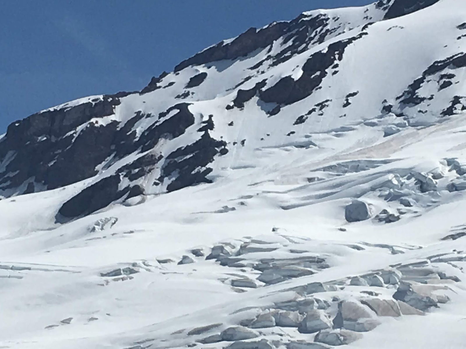
Once gaining Boulder Ridge the snowpack dominates the landscape with no dry campsites. Sun cups up to 6500 feet then smooth soft corn up to our high point, 9000 feet. Minimal boot and ski traffic was observed up to 8000 feet. The soft corn allowed us to skin to our high point. Don’t let your guard down; be mindful of thinly covered moats near exposed rocks on the ridge. Beyond our high point is only speculation but the route appeared to connect to the summit. Observed crevasses above 9000 feet beginning to appear.
Skiing:
We skied two runs: The first run was from 8000 to 7000 feet. Snow was soft corn and a little dirty and sticky. We experienced clean smooth snow from the last snow storm above 8000 feet. Skied continuously to the rappel station near 4600 feet and a few hundred vert below. Switched back to hiking boots at 4000 feet.
Road Access: Road #12 and #13 were open and clear to
Schriebers Meadow Trailhead.
Trail Status: Scott Paul Trail was snow free to the junction
with the climber’s trail. The climber’s trail was partly snow free to Cragview
Camps.
Snow Level: 6500ft
Snow Observations: Corn snow at all elevations with some
refreezing occurring overnight.
Route Observations and Additional Information: Several
climbing parties made ascents of the Squak Glacier over the weekend, although
the route was a little different than usual. Guides reported that a large
system of crevasses at approximately 9000 feet made the traditional route
unfeasible. As an alternative, climbing parties ascended the Squak Glacier to
approximately 8500 feet and then made a westerly traverse to the upper section
of the Easton Glacier route. This traverse was reportedly straightforward and
in great condition, connecting to the Easton route at roughly 8700 feet. This
is a great option for those who would like to see a less populated part of the
mountain.
Cragview Camps and the Metcalf Moraine were reportedly partly
snow free with several dry tent pads available. Running water wasn’t
immediately obvious but could be found with a bit of searching.
As always, please pack out all garbage and human waste using
blue bags or another system. This is a very sensitive area and visitors must be
diligent with their LNT practices. If you notice other visitors who are not
packing out their waste, please inform them of the pack-it-out policy. Help us
keep the mountain and our water sources clean! Thanks and happy climbing!
MAJOR OBJECTIVE HAZARDS: Hanging ice and loose rock on Coleman-Deming route.
Road Access: Glacier Creek Road was open and clear to
Heliotrope Ridge trailhead.
Trail Status: Heliotrope Ridge Trail was in good shape and
was snow free to Harrison and Hogsback camps, and the glacier overlook.
Snow Level: Approximately 5500ft
Snow Observations: Soft corn snow at most elevations with
some dry glacier beginning to appear on parts of the route. Suncups developing
below 7500 feet.
Route Observations and Additional Information:
IMPORTANT NOTICE: MAJOR OBJECTIVE HAZARDS ON COLEMAN-DEMING
ROUTE. On Thursday, June 13, a snow bridge spanning a large crevasse at
approximately 8800 feet on the Coleman-Deming route collapsed. This bridge had
been the main route across the crevasse. As an alternative, some climbing
parties chose to end run the crevasse to the climber’s left. However, this
route travels close to hanging ice and loose rock in the area known as the
Roman Mustache. These are major objective hazards that should not be
underestimated. They have the potential to collapse without warning, possibly
causing serious injury or death.
The 8800-foot crevasse has been a common problem in recent
years. Last August, this same area became essentially impassible to most
climbers except those with a high level of technical skill. This year, the same
issues are happening earlier. Although climbing parties were able to complete
summit climbs via the end run, exposure to such large overhead hazards should
not be taken lightly.
Do not camp or take breaks anywhere near this hazard.
Additionally, the hanging glacier on Colfax Peak has significant
cracks developing near its edges, which indicates a large collapse could happen
in the future. Last year, in late July, a very large collapse here caused an
ice avalanche that completely covered the main climbing route with debris. A
similar event is possible and even likely this year.
This brings up an important reminder to all climbers on any
route: get an early alpine start to your summit bid and make sure to return to
camp before midday.
However, no amount of skill, speed, or planning can
completely eliminate the objective hazards that are present on the current Coleman-Deming
route. Just because other parties made it through there does not mean it is
safe! Don’t let summit fever cloud your judgement. The climbing rangers
encourage parties to consider other routes on Mount Baker, such as the Easton
Glacier.
Alternatively, ice climbing on the Coleman seracs or
practicing rescue skills on the lower glacier are great ways to enjoy the
Heliotrope Ridge area. Hogsback Camp has 20-30 dry tent pads and running water
is readily available.
Remember to pack out all garbage and human waste! Rangers
removed large amounts of waste from the Football Field and Black Buttes area.
Waste buried in the snow will melt out and contaminate water sources. Blue bags
are available for free from the USFS visitor center in Glacier or from
trailhead dispensers. Thanks for helping us keep Mount Baker clean! Happy
climbing!
Coleman-Deming Galcier -June 1, 2019
Coleman-Deming Camp and Route Conditions
Road Access: Glacier Creek Road was open and clear to Heliotrope Ridge trailhead.
Trail Status:Heliotrope Ridge Trail was in good shape and was mostly snow free to Harrison and Hogsback camps, and the glacier overlook. The few patches of snow that do remain will melt quickly.
Snow Level:Approximately 5500ft
Snow Observations:Soft corn snow at most elevations with some dry glacier beginning to appear on parts of the route. Skiers who descended at 11am reported icy conditions on the Roman Wall, with nice corn on lower pitches.
Route Observations and Additional Information:The Coleman-Deming Route saw a lot of traffic from climbers, skiers, and snowboarders this weekend. The route was generally well covered and direct, although a few significant crevasses are beginning to appear and the route will likely change soon. Some parties were observed traveling over a thin snow bridge at approximately 7500 feet. Early in the season, while the glacier is still covered with the winter snowpack, it should not be necessary to travel over precarious bridges. There was a much safer route through this area a short distance to the climber’s right. Take your time to find the safest route.
Crossing thin snow bridges early in the season is not necessary. Find a safer route!
Pumice Ridge was still snow covered and the bootpack up the Roman Wall was in good shape. Skiers and snowboarders should remember not to side slip on top of the bootpack when descending the Roman Wall or other parts of the route. This can endanger those ascending and demolish the bootpack. Ski to the sides and stay in control.
There were around a dozen dry tent pads at Hogsback Camp and more will be melting out very soon. Running water was available nearby. Please remember to pack out all garbage and human waste using blue bags or another system. Happy climbing!
Coleman-Deming Glacier - May 20, 2019
Hogsback Camp conditions. May 18, 2019
Road Access: Glacier Creek Road is open and clear to Heliotrope Ridge Trailhead.
Trail Status: Heliotrope Ridge Trail is mostly snow free to Kulshan Creek and mostly snow covered thereafter. One downed tree is still across the trail and has to be climbed over. Trail is otherwise in great condition.
Snow Level: Approximately 5000ft
Snow Observations: Soft corn snow at lower elevations with icy sections higher up.
Route Observations and Additional Information: The Coleman-Deming route saw a lot of traffic from climbers and skiers this weekend. The glacier was generally well covered and there were several inches of fresh snow on top of a harder surface. Guides reported a crevasse intersecting the bootpack at approximately 8500 feet, below Coleman Saddle. Two ice avalanches also occurred in this area on the same day, from Colfax Peak and the Roman Mustache. This is one of the most hazardous sections of the route every year, so remember to move through there efficiently. Pumice Ridge is still covered with snow. Skiers reported icy conditions on the Roman Wall. All teams experienced high winds and cold temperatures.
There were a few dry sites at Hogsback Camp and running water was available nearby, but the area is still mostly snow covered.
As always, pack out all garbage and human waste using blue bags or another system. Help us protect our water sources and keep the mountain clean for future visitors. Thanks and happy climbing!
Coleman-Deming Glacier - May 17, 2019
Looking up Heliotrope Ridge Trail toward Hogsback Camp. Dangerous moat marked with red arrow. Bootpack/trail visible on left side of photo.
Close up of the moat.
The climbing rangers would like to remind all climbers, skiers, and hikers about a common hazard on Heliotrope Ridge Trail, the approach to the Coleman-Deming, North Ridge, and Coleman Headwall routes. This time of year, the melting snowpack creates a dangerous moat in the Kulshan Creek drainage to the west of Hogsback Ridge at about 5400 feet. Later in the summer when the snowpack is gone, it is a large waterfall, but this time of year it can look like a small crack where the snow is peeling back from the rock. This moat was the site of a fatality several years ago.
People tend to ski and glissade directly down the drainage, but the moat cannot be seen from above until you're right on top of it. The moat can be as deep as 40 feet. We encourage all visitors to avoid the drainage and stick to the ridge until well away from this hazard. And don't hesitate to inform other visitors about the moat. Be safe and enjoy your time on Mount Baker!